New York: If you’re in San Antonio or nearby, you’ve probably heard the buzz—tornado warnings, flash floods, and dangerous storms are dominating the weather today. It’s not just another rainy day. Overnight and early morning alerts have put the city on edge, especially in northwest Bexar County and surrounding areas.
People have reported flooded roads, fast-rising streams, and booming thunderstorms all night. And although no tornado has touched down as of now, a brief tornado warning issued late last night made it clear—this storm system means business. With flash flood warnings still in effect, many are wondering what to expect next and how to stay safe.
If you’re feeling uncertain or overwhelmed by all the radar alerts and storm jargon—don’t worry. We’ve broken down the latest updates, what they really mean, and how you can prepare and protect yourself.
Current Tornado Warning in San Antonio: What We Know
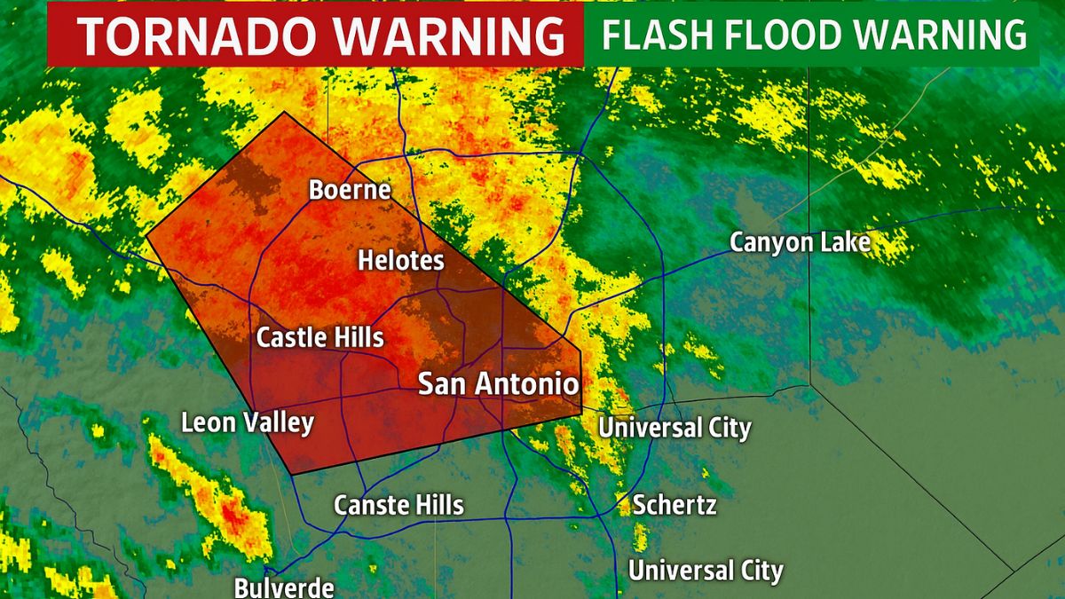
As of late Wednesday night (June 11), a Tornado Warning was issued for parts of northwest San Antonio, including Leon Valley, Helotes, and Castle Hills. The National Weather Service (NWS) picked up rotation on Doppler radar, prompting the warning—but thankfully, no confirmed touchdown occurred.
That warning was allowed to expire shortly after midnight, but the risk of more severe thunderstorms remains. Additional watches or warnings could be re-issued depending on how the storm evolves through the day.
Flash Flood Warning Remains in Effect
San Antonio’s bigger threat right now? Flash flooding.
Multiple Flash Flood Warnings remain active across Bexar, Comal, Hays, Kendall, and Guadalupe counties. According to the NWS:
- 2 to 4 inches of rain has already fallen in some areas.
- In isolated spots like Spring Branch, rainfall rates have reached 5.5 inches per hour.
- Rain totals could reach up to 7 inches in some storm-hit zones.
Important Tip: Never drive through flooded roads—“Turn around, don’t drown” is serious advice. Even 6 inches of fast-moving water can sweep a car away.
What Areas Are Affected?
Here’s a snapshot of where flooding and storms have been most intense:
- San Antonio (northwest & northeastern parts)
- Boerne
- Canyon Lake
- Spring Branch
- Helotes
- Leon Valley
- Fair Oaks Ranch
- Bulverde
- Schertz
- Universal City
- New Braunfels
If you’re in one of these zones, stay alert to local broadcasts or weather apps.
Tornado Watch vs Tornado Warning – What’s the Difference?
If you’re confused between all the watches and warnings—you’re not alone.
| Term | What It Means | What to Do |
| Tornado Watch | Conditions are favorable for tornadoes |
Stay alert; review safety plans
|
| Tornado Warning | A tornado is spotted or radar-indicated |
Take immediate shelter
|
| Flash Flood Watch | Potential for heavy rain/flooding |
Monitor alerts, avoid low-lying areas
|
| Flash Flood Warning | Flooding is occurring or imminent |
Move to higher ground now
|
Safety Tips if You’re in the Affected Area
- Stay indoors. Avoid driving unless absolutely necessary.
- Charge your phone and keep your weather alerts turned on.
- Move valuables away from ground-level or basement storage.
- Avoid creeks, streams, and underpasses. They flood fastest.
- Keep flashlights and first-aid kits handy. Power outages are possible.
Pro Tip: Have an emergency bag ready. Include water bottles, medication, ID copies, power banks, a flashlight, and basic hygiene items.
What to Expect for the Rest of the Day
The latest forecasts suggest more rounds of heavy rain and possible thunderstorms through the afternoon and evening. While the tornado threat has eased, new flash flood warnings could pop up with little notice.
According to local meteorologists, the storm system is slow-moving and interacting with Gulf moisture, which increases the risk of repeat rainfall in already-soaked areas.
Helpful Resources
Live Radar: Check your local TV station apps (like KSAT, News4SA)
NWS Alerts: https://www.weather.gov/safety
Flood Map San Antonio: https://www.bexarflood.org
While the tornado scare has passed for now, San Antonio isn’t out of the woods. Flash flooding is still a major concern throughout Thursday. Stay weather-aware, avoid risky travel, and prioritize safety above all else.