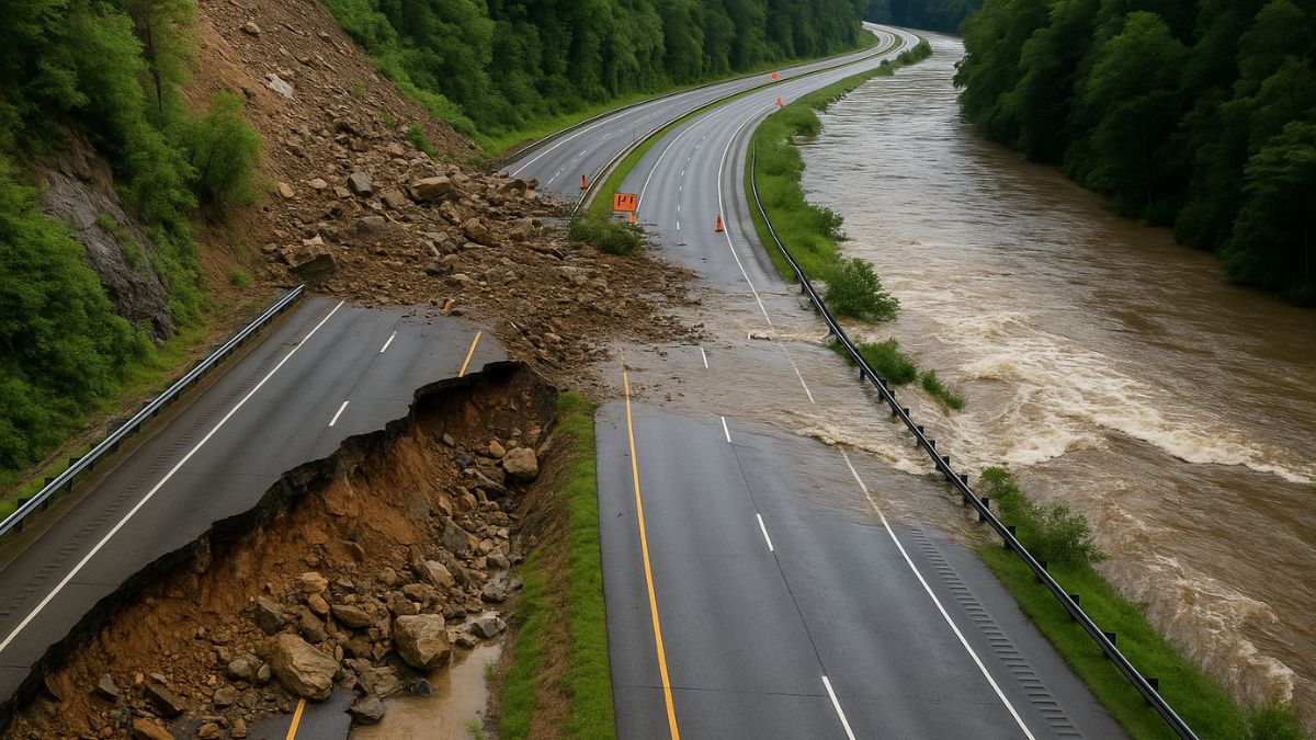
New York: If you’ve ever road-tripped through the scenic stretch of I‑40 along the Tennessee–North Carolina border, right near the Pigeon River Gorge, you’ve seen the beauty—and felt the bumps. Now, Mother Nature has taken things to another level. Heavy flash flooding and a sudden rockslide have shut down both directions of I‑40 at Mile Marker 450 in Cocke County, Tennessee, and just past Exit 20 in Haywood County, North Carolina. It’s dramatic—and totally real.
For many, that interstate closure isn’t just a roadblock—it’s a ripple effect. From delay-postponed gigs to rerouted road-trips, suddenly you’re Googling detours and filling your gas tank on I‑26 or I‑81. Let’s peel back the layers: why this happened, how bad the damage is, and what it means for anyone currently planning to cross state lines.
We’re going deep—no fluff. Expect an actionable guide, emotional clarity, and good vibes (because you’re gonna need them when your favorite playlists reroute). Consider this your one-stop update for all things I‑40 closure.
Also Read: Is Juneteenth a Federal Holiday? Yes—And Here’s Why That Matters
What Caused the I‑40 Road Closure? Flash Flooding & Rockslide Explained
In a massive geological “double-whammy,” flash floods from torrential rain saturated the mountainsides. Combined with unstable slopes, rockslides dropped debris onto the roadway. TDOT confirmed a landslide just east of Exit 451 (Waterville Road) and flooding blocked both directions near MM 450–452.
Current Status of I‑40 Closure: Where It’s Blocked & Who’s Assessing Damage
The closure starts at mile marker 450 in Cocke County and continues west through Exit 20 on the North Carolina side . Crews from TDOT and NCDOT have been on-site since June 18, clearing mud and debris, and awaiting water levels to recede before a full inspection.
What’s the Timeline for Reopening I‑40?
The reopening estimate isn’t set in stone. Traffic officials reported they’ll only know after water drops and engineers assess the slopes . Based on past events—like post-Helene repairs—partial reopening took months, with permanent fixes stretching into 2026–2028.
Approved Detour Routes for Tennessee‑North Carolina Travelers
- I-40 Eastbound: Exit at Hartford Road (Exit 447), take I‑81 N to I‑26 E.
- I‑40 West/North Carolina side: Exit at 20, switch to I‑240 W → I‑26 W → I‑81 S.
- Drivers from Winston‑Salem or Statesville: via US‑52 → I‑74 → I‑77 → reconnect with I‑81 in Virginia, then back to I‑40 at MM 421.
Why Pigeon River Gorge Is a Hotspot for I‑40 Road Closures
This gorge is a fatal attraction for floods and slides. It cuts through steep mountain faces, sits next to the Pigeon River, and lacks wide shoulders. Geological records show recurring closures in 1985, 1997, 2009, 2012… Heck, rockslides shut the road for months back in 1997–2010.
How Travelers Are Handling It – Emotional & Practical Fallout
Local drivers share the frustration. One stranded woman told WVLT she sat for hours after floods trapped her car. But communities are rallying—TDOT is posting live updates, and interstate long-haul networks are updating truckers in real time. Still, some tech-earners found Zoom gigs slipping thanks to live delays. It’s more than road rage—it’s real life interference.
Pro Tips for Your Next Pigeon River Adventure—Without the Detours
- Check real-time via TDOT/NCDOT apps before heading out.
- Pack snacks, gas up near exit 447 if eastbound.
- Share your ETA with friends; delays here can stretch hours.
- Check weather updates: another storm could elongate the closure timeline.
This is more than travel news—it’s a real impact story. Keep checking state DOTs, plan ahead, and don’t let a closed interstate close off your plans. Stay safe out there.